
The Ecological Benefits of Using Drones for Large-Scale Habitat Mapping
With increasing pressure from development, biodiversity net gain (BNG) requirements and the weakening of environmental protection through the Planning and Infrastructure act 2025, we as ecologists require accurate landscape scale information more now, than ever. At Ecotainment, we’re shaping how drones are used in ecology, as an essential tool, complementing traditional field surveys and significantly improving how habitats are assessed, mapped and monitored.
1. Assessing Areas with Limited access
Drones allow us as ecologists to gather preliminary habitat data remotely, ensuring ecological features are identified early in the planning process without trespass or ground disturbance. As drone pilots, we’re legally allowed to fly over land with restricted access, provided operations are conducted in line with CAA regulations, airspace restrictions and privacy requirements. This enables early habitat identification and improved survey scoping for largescale schemes,
2. Landscape-Scale Ecological Understanding
Drones enable ecologists to assess entire sites and surrounding landscapes rather than isolated parcels of land. High-resolution aerial imagery allows habitats to be viewed in context, revealing ecological connectivity, edge effects, fragmentation and wildlife corridors that may be missed during ground surveys alone.
This broader ecological perspective is particularly valuable for large developments, where off-site impacts and habitat linkages are critical to mitigation and enhancement strategies.
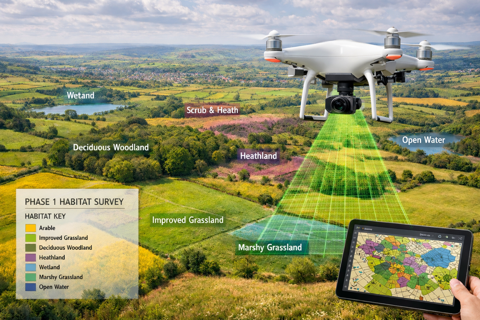
3. Improved Habitat Identification and UKHab Mapping
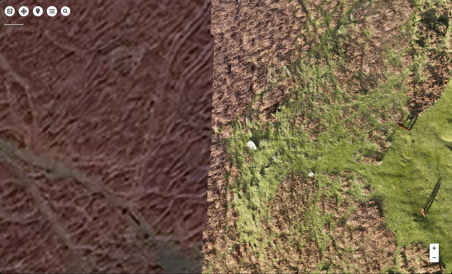
Drone imagery supports more accurate UK Habitat Classification (UKHab) mapping by providing detailed, geo-referenced orthomosaics of a site, these can be imported directly in GIS for us in the office. Habitat boundaries can be mapped precisely, and subtle changes in vegetation structure, moisture or management can be identified before targeted walkover surveys are undertaken.
For us as ecologists, this means field time can be focused on ground truthing, condition assessment and species-specific surveys, rather than spending our time on site mapping habitats. At Ecotainment, we’re often asked if there is much of a difference between drone data and google earth, YES there is.
4. Supporting Robust Biodiversity Net Gain (BNG) Assessments
BNG calculations rely on accurate baseline habitat data. Drones provide consistent, repeatable measurements of habitat extent and configuration, reducing uncertainty in baseline assessments.
Ecology drones are also ideal tools for monitoring habitat creation and enhancement post-consent, allowing ecologists to assess establishment success, management outcomes and long-term ecological change with minimal disturbance.
5. Reduced Disturbance to Sensitive Habitats and Species
Repeated site access can damage sensitive habitats and disturb wildlife, particularly during the breeding season. Drone surveys reduce the need for extensive footfall across sites by survey teams (ecology, geotech, transport, Civils etc), helping all disciplines collect essential data while minimising ecological impact.
6. Access to Hazardous Areas
Many ecologically valuable areas are challenging or unsafe to access on foot, such as adjacent to highways, waterbodies, steep slopes, unstable ground and brownfield sites. Drones allow us as ecologists to safely assess these without compromising data quality or personal safety.
7. Stronger Evidence for Ecological Reporting and Planning
Drone-derived habitat maps provide clear, visual evidence that strengthens ecological reports, Ecological Impact Assessments (EcIAs) and planning submissions. Orthomosaics, 3D maps and annotated habitat maps help planners and stakeholders understand ecological constraints and opportunities, supporting informed decision-making.
8. Creating Long-Term Ecological Baselines
Drone surveys create a permanent digital record of site conditions at a specific point in time. This data can be revisited for future monitoring, adaptive management and compliance checks, providing continuity across project phases.
If you have any questions about the us of drones in ecology, get in touch via Contact@ecotainment.co.uk.